07 August 2019
Uniting Global & Hyper Local Data For Land
How can data generated by TIMBY work with global repositories to benefit communities tackling land issues?
Back to BlogsOver the past years there has been a rapid increase of land-related datasets, including The Land Matrix, Landex, Global Forest Watch, Moabi, MapHubs, as well as high temporal and spatial satellite imagery from places like Airbus and Planet Labs. These are incredible resources. Yet some questions remain on how these resources can be used to fuel action on the ground, and whether there is any role for hyperlocal data generated by groups on the ground to feedback into these datasets.
To help tackle these questions, TIMBY was invited to host a panel discussion during the annual LANDac Conference, presented by the Netherlands Academy on Land Governance for Equitable and Sustainable Development in Utrecht. The event brought together researchers, policy makers, development practitioners, and business professionals in the field of land governance and development, under the thematic area: “Land Governance in Transition: How to support transformations work for people and nature”
During the first day of the conference, TIMBY hosted a session with representatives from The Land Matrix, LANDex, and Jusi.Py to discuss examples of monitoring initiatives and tools used both on the global and hyper-local levels for land issues, and how they can be mobilised to work more effectively together. The session covered the practical and technical questions about how to include local groups, many of whom are in offline areas and have limited digital literacy, in evidence gathering. Here are some of the takeaway points from the discussion:
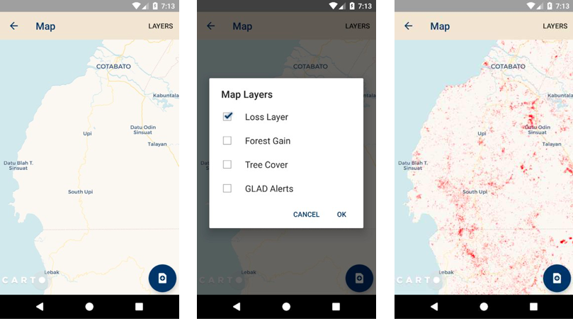
Monitoring technologies such as TIMBY can be tailored to collect data (tags, photos, videos, audio) that relate to internationally recognised principles and variables and indicators of global datasets, such as Global Forest Watch, The Land Matrix. The practicalities of integrating data generated from monitors on the ground with global data sets are complex. How do we link regularly updated satellite data and imagery on global platforms with the collection of data from communities at the frontline of land issues who are so often in areas with little to no data/Wifi coverage? Additionally, satellite imagery can cover a huge geographical area in comparison to monitoring projects involving reports and evidence being collected by communities. Functionalities such as TIMBY’s offline map allow monitors on the ground to visualise and use mapping layers (forestry concessions, land boundaries etc) from databases such as GFW on their reporting devices even when they are not connected to data/Wifi. Activities such as these go some way to allowing global datasets work for and benefit those ‘on the ground’, but there is still work to be done the other way around.
This is just a snapshot of some of the issues and questions surrounding the topic of how data can be mobilised on a local level and scaled up for use in global data sets, and also how global data sets can be accessible to non-specialists on the ground. TIMBY’s position is that global repositories that attempt to democratise land monitoring, elevate voices, and provide transparency of land governance should not simply operate in a top-down approach, but actively include and feedback narratives and stories from those on the ground (photos, videos, audio) in a safe and secure way. Many practical and technical questions remain as to how compatible or incompatible global and hyper-local data in monitoring tools are, but TIMBY is at the forefront of engaging with communities to make technology advances work for them.